
Your Custom Text Here
Governor Hogan: Promises Won't Protect Our Homes
An open letter...
The Honorable Governor Larry Hogan
100 State Circle
Annapolis, Maryland
21401-1925
Dear Governor Hogan,
Thank you for speaking with me at the Gaithersburg Labor Day Parade about the I-270 and I-495 project. I was very encouraged to hear you say that “Not a single house is ever gonna be taken down” to make room for widening of the highways. I was further encouraged that you repeated the sentiment to news organizations WTOP and www.mymcmedia.org/.
However, the official documents and statements from your Administration, specifically the Maryland Department of Transportation (MDOT) and the State Highway Administration (SHA), leave wide open the possibility that private property could be seized and homes paved over.
A slide presented to project bidders during a December 13, 2017 “Industry Forum” highlighted the question of who assumes the cost risks of “Right-of-way acquisition.” MDOT explains this as the process of seizing property, assessing its value, negotiating over compensation and relocation. Clearly from the State’s perspective, “right-of-way” acquisition includes the taking of private property to make room for transportation projects. How do we know that this won't be used to take homes?
Even the statement issued by SHA on Tuesday, September 4th in response to questions about your “Not one single house is ever gonna be taken down” undercuts your promise. The SHA statement says that the state’s “approach” is to develop options “within the existing right-of-way.” The statement does not rule out property seizures or paving over homes, since it characterizes the state’s position as an “approach” which does not guarantee that’s what will happen. In addition, if the state’s intention is to stay within the right-of-way, why has right-of-way acquisition been a topic it has needed to discuss with bidders, and why is it so important to figure out “who assumes the cost risk?”
Governor Hogan, promises won't protect our homes. If you mean what are saying, make it official: direct MDOT and the SHA to inform bidders that proposals that involve seizing property or tearing down or moving existing homes will not be considered.
Thank you for your time and attention, and please reply to let me know what you plan to do.
Peter Altman
(street address withheld from web version)
Rockville MD 20850
Governor Hogan Responds to I-270, I-495 Protesters Worried About Homes
A big concern of those living near I-270 and I-495 is the prospect homes and neighborhoods being paved over to make room for Governor Hogan's huge highway project. The Governor proposes adding as many as four lanes to both highways. This has a lot of local residents anxious about the impacts on their homes, neighborhoods and communities, since widening the highways, which run right up against neighborhoods and property lines, would seem to require taking down homes to make room for more lanes.
And according to the Montgomery County Planning Committee, the State's "Managed Lanes Study Area" will ultimately evaluate properties and resources within approximately 300 feet of the existing I-495 and I-270 highway centerline, which certainly suggests that, in the end, stuff would have to be moved out of the way.
So protestors from neighborhoods next to and near I-495 and I-270 arranged themselves along the Labor Day Parade routes in Kensington and Gaithersburg MD. I had a chance to ask the Governor about the risk to homes along the highways. Here's the video (apologies for the very out-of-frame cinematography here):
While we're glad that the Governor told a protester this in the middle of a parade, we'll all feel a lot more secure in our homes' and neighborhoods future if he would issue a formal statement saying so, and making clear to bidders on the project that they will not be able to use eminent domain to seize property. Because as these maps show, there are a lot of homes in the "Study Area". Then we'll all be able to relax.
What Homes are Inside the “Study Area” for Widening I-270 and I-495?
One of the biggest questions concerning Governor Hogan’s plan to widen I-270 and I-495 is “How many and whose homes will be seized and paved over in order to add lanes?” I’ve starting mapping neighborhoods along I-270 and I-495, marking the boundaries of the State’s study area.
UPDATE (Nov 3, 2018) The Maryland-National Parks and Planning Commission just posted a searchable online map showing the extent of the current rights-of-way (ROW) for I-270 and I-495. Currently, the Maryland Department of Transportation (MDOT) is saying it intends to keep any changes to the roads within the existing ROW. You can use the map to see whether properties would be affected - if MDOT sticks to that promise. If you haven't already, please sign our petition calling on Governor Hogan to direct MDOT to reject any proposal which would involve taking homes or property.
One of the most persistent questions that County and City officials, citizen groups and citizens themselves have had about plans to widen I-270 and I-495 has been “just how much wider are we talking about?”
But the State has so far refused to provide any concrete answers, even when directly questioned. As the Maryland Transit Opportunities Coalition (MTOC) highlights, State officials refused to answer questions from the Montgomery County Planning Council during a recent briefing. When MTOC asked for the information under the Maryland Public Information Act the State responded that the non-profit citizen group would have to pony up over $6,000 if they wanted a response. That’s a pretty steep price to pay for information generated with taxpayer dollars that could result in taxpayer homes being torn down.
But State officials have been keen to avoid providing any specifics about how much the roads might need to be widened. Over the course of eleven public meetings and briefings, the State hasn’t once revealed any concrete information about how much wider the highways would need to be in order to accommodate new toll lanes.
Adding to the confusion created by the State holding back on telling the public how much wider the road would get, we’re now getting conflicting statements about whether the highways even would expand. When he announced the plan nearly a year ago, Governor Hogan explained that “These three massive, unprecedented projects to widen I-495, I-270 and MD 295 will be absolutely transformative…”
But last week, the Washington Post paraphrased Maryland State Highway Administrator Greg Slater as saying that “the state plans to keep any changes within the existing right-of-way.”
I’m no road expert, but it seems like it’d be hard to squeeze four extra lanes into a highway without making it any wider. Hey, if Slater is right, I’ll be thrilled. But until we know for sure, residents need to know who might be affected.
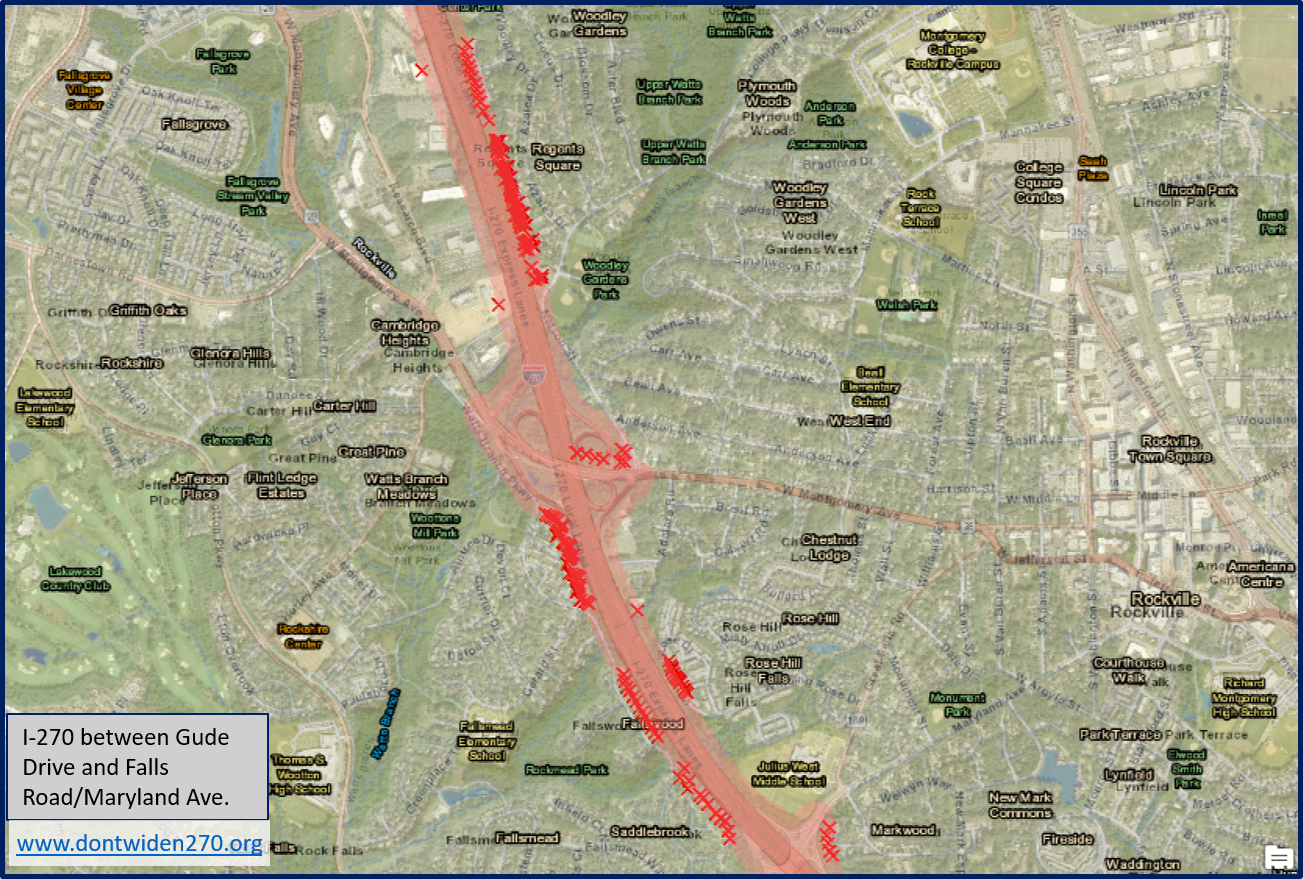
What we do know is that the State’s Managed Lanes study will “ultimately evaluate properties and resources within approximately 300 feet of the existing I-495 and I-270 highway centerline.” Now, that doesn’t mean they are going to pave over everything in that area. But they are studying something, and until the State decides to come forward with concrete information, at least we can get started looking at possible impacts using the 300 feet figure.
To that end, I’ve started producing GIS maps along the highway, highlighting the area the State is studying. I’ve done my best to show the buffer extending 300 feet from the centerline of the highway on each side, and what homes and businesses may be in that area. It’s a lot of mapping, so I’m going in segments. The first set I’m posting show I-270 from south of Gude Road to Falls Road/Maryland Avenue. I’ll post more areas and neighborhoods as I get them mapped.

The stretch of I-270 between Gude Drive and Falls Road/Maryland Avenue is home to many neighborhoods within the study area. More detailed illustrations of individual neighborhoods are below. (PS Let me know if I got any neighborhood names wrong.)


